
Ontario: Geological Stories From Fraserdale Glacial Drift
This note is a very simple description of what a geologist sees in the glacial drift present around the Fraserdale area, Ontario (Photo 1). The description is not intended to be comprehensive and it is not intended for the expert geologist. My intent is to share with you the type of simple geological insight that can be gained by looking at what lies beneath your feet.
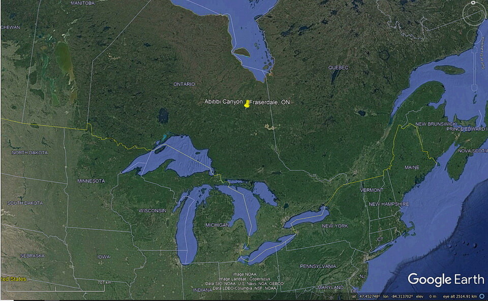
Photo 1: This Google Earth map gives you a geographic context for the Fraserdale - Abitibi Canyon area, Ontario, Canada. Fraserdale is located about 130 kilometres (81 mi) north of Timmins, about 160 km (100 mi) south of James Bay.
What Is Glacial Drift?
Glacial drift is a general term used to describe all rock material, such as clay, silt, sand, gravel, boulders, that is found anywhere and that is transported by a glacier. Glacial drift is deposited directly by, or from, the glacial ice or by running water emanating from a glacier. Glacial drift is of glacial origin. The term “glacial origin” refers to erosion, transportation and deposition by glaciers. Glacial sediment can be used synonymously with glacial drift.
So, in this note, I speak in general terms about the unconsolidated, sandy and gravelly glacial drift material that is exposed on the land surface near Fraserdale, Ontario (Photo 2).
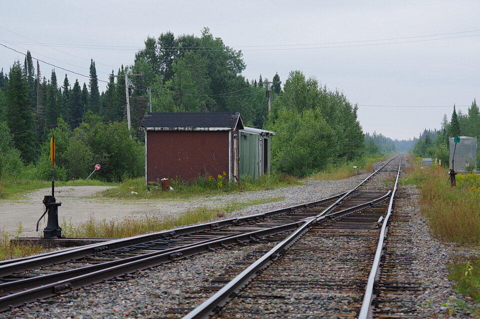
Photo 2: Fraserdale is a whistle stop along the Ontario Northland railroad and a jumping-off place for wilderness canoe trips along the great northern rivers to Moosonee, on James Bay. Photo composed by Andy Fyon, Aug. 10/21.
Part 1: Seasoned Travellers
You can think of pebbles contained in glacial drift as travellers. Why? The glaciers moved those rocks over great distances and likely more than once.
The last ice age ended about 15,000 to 10,000 years ago, depending where you are located in Canada. That last ice age is called the Wisconsin Glacial Episode, or the Wisconsin glaciation for short. During the last ice age, glaciers scraped over the bedrock and plucked out pieces of rock. The glacier polished the bedrock rock surface by grinding off dust-sized grains of rock - a bit like using sandpaper to grind down and polish a piece of wood. Some of that removed rock flour was transported and deposited beneath by the glacier (e.g., glacial till). Some rock pieces were moved again and redeposited by rivers that flowed beneath the glacier to form eskers. And some rock pieces were deposited on flat sand and gravel flat plains on the land surface by rivers created by melting ice sheets. Large lakes formed in front of the glacier on the land liberated by the melting ice sheet. Where meltwater rivers flowed into one of those large lakes, some of the transported rock pieces were deposited as a delta and the suspended clay- and silt-sized rock flour ultimately settled to the bottom of the lake, when the river lost its energy and its ability to carry the ground up rock dust. A good geological eye can read this complex story, although my one good eye reads poorly, so I offer the simple story version LOL.
Many different rock types make up the bedrock in the broad Fraserdale area. Those different rock types are seen in the gravel deposits left at the end of the ice age - sort of a train ticket presented by each different rock type. Each different rock type represents a different journey travelled from a different place. When you walk and look at the land beneath your feet, you begin to see some of that history created at the end of the ice age.
One part of that glacial drift history is visible on the land surface (Photo 3). Light- and dark-coloured pebbles occur in this glacial drift deposit. Each different colour reflects a different bedrock rock type that the glacier scrapped over. About 60-80% of the pebbles are light coloured. They were plucked from the “young”, 550 to 360 million-year-old limestone and dolostone rocks that occur as an apron beneath, and on the south side of, Hudson Bay and beneath, and on the east side of, James Bay. These are transported pieces of Hudson and James bay lowland rocks. Some of the dark coloured pebbles also appear to be transported pieces of lowland rocks, but a smaller percentage of the dark rocks may have come from the nearby old Canadian Shield rocks that are older than 2,500 million years in age.
You are looking at seasoned rock travellers. All of the pebbles originated somewhere else, to the north, and were carried south to the Fraserdale area. Some rocks have travelled 10’s of kilometers. Others likely travelled hundreds of kilometers. And some travelled more than once - see Part 2 below.
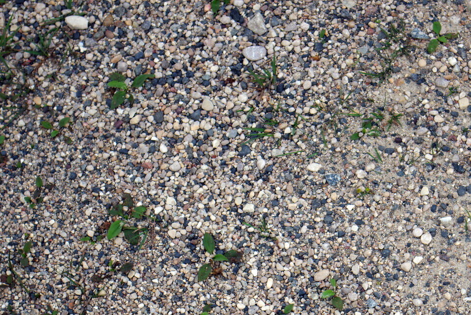
Photo 3: Light- and dark-coloured pebbles occur in this deposit. Each different colour reflects a different bedrock rock type that the glacier scrapped over. About 60-80% of the pebbles are light coloured. They were plucked from the “young”, 550 to 360 million-year-old limestone and dolostone rocks that occur as an apron beneath, and on the south side of, Hudson Bay and beneath, and on the east side of, James Bay. These are Hudson and James bay lowland rocks. Some of the dark coloured pebbles also appear to be lowland rocks, but a smaller percentage of the dark rocks may have come from the old Canadian Shield rocks that are older than 2,500 million years in age.
Part 2: Don’t be Square, Let’s Rock and Roll
This Part 2 of the note follows looks at some evidence telling us that water was an important vehicle that transported many of the rock pieces in the glacial drift. During, and at the end of, the Wisconsin Glacial Episode, glaciers and melt water rivers moved a lot of rock around. Pieces of rock were plucked out of the bedrock. Some of those plucked rocks were transported by rivers that flowed beneath the glacier to form eskers and some rocks were moved across the land by rivers created by the melting ice sheets. It can be hard to tell exactly how a rock fragment moved, but there are two clues used to tell if a rock piece was moved by water - that is the smoothness of the rock surface and the shape of the rock piece.
Most pebbles in this glacial drift have a smooth, curved surface (Photo 4). Some pebbles are round. Others pebbles are elliptical or egg shaped. Most have smooth curved surfaces.
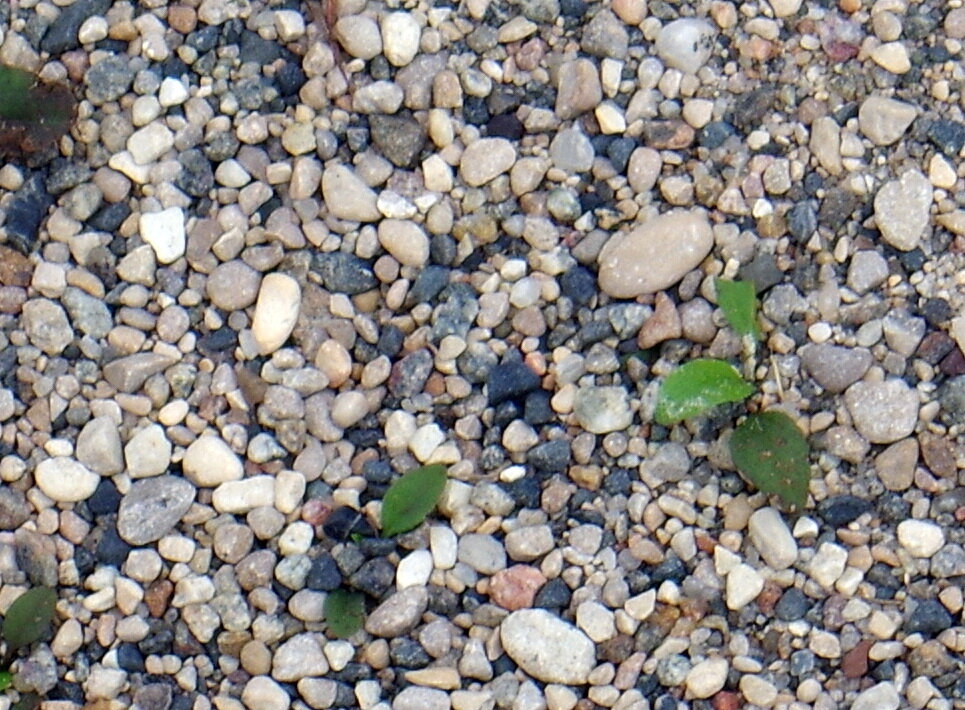
Photo 4: Most pebbles in this glacial drift have a smooth, curved surface. Some pebbles are round. Others pebbles are elliptical or egg shaped. The smoothness and the the shape of the surface of the rock pieces is an indication that the rock fragments were moved by water flowing in a river. Photo composed in Fraserdale by Andy Fyon, Aug. 10/21.
The shape and the smooth curved surface of the rock fragments usually means the rock pebbles were carried by water, likely in a river. As the rock fragments travelled and rolled along the river bed, the rocks bumped against each other. Sharp edges were quickly worn away. The rock was transformed from a square shape with sharp angular edges, into a round or egg shape with smooth, curved edges. These physical features are an indication that the rock was transported by river water. It is also likely that those pebbles travelled more than once. The first journey took place immediately after the rock fragment was plucked from the bedrock. Later journeys involved travel driven by the power of moving river water. A good geological eye can read a more complex story, but, as I said, my one good eye reads poorly, so I offer the simple story.
Yes, these pebbles are seasoned rock travellers. They are no longer square with sharp edges. Many now show smooth surfaces indicative of “rocking and rolling” along the ancient river beds.
Summary
In areas covered by glacial drift, where bedrock is poorly exposed, or not exposed at all, insights into the bedrock types that occur in a region are gained by looking at the types of rock fragments that occur in the glacial drift. Furthermore, the rock shape and the presence of a smooth, curved surface on each rock fragment help tell us that river water was an important transport vehicle of the rock pieces plucked from the bedrock.
We can learn a lot by looking at the geological material beneath our feet.
Aug 29/21.