Ontario: Geology and Weather: Freezing Rain, Ottawa Area
Grabens and Cold Air
Ottawa, Ontario, Canada, gets its share of unusual weather. Freezing rain is one of those gifts. Did you know there is a link between the local geology and freezing rain in the Ottawa area?
Sometimes you hear the weather person comment that the cold air in the Ottawa Valley may result in freezing rain for the Ottawa area. Here is how it works. The eastern part of the land we call North America, in the area where Ottawa now sits, started to pull apart about 500 million years ago. A rift formed. If the rifting continued, an ocean would have formed. In this case, the rifting froze, or failed, and the result was a geological valley called the Ottawa-Bonnechere Graben. This graben is about 700 km long and about 55 km wide (see photo 1).
Photo 1: Map of the Ottawa-Bonnechere and Timiskaming grabens, located near the City of Ottawa, Ontario, Canada. Image source: https://commons.wikimedia.org/wiki/File:Ottawabonnecheregrabenmap.png
The Ottawa - Bonnechere Graben is bounded on the north by the Mattawa Fault and on the south by the Petawawa Fault (Photo 1). The Ottawa River flows along the graben valley today.
Cold - Warm Air
Freezing cold air is dense. It sinks because it is heavy. When freezing cold air floods into the Ottawa area, the cold air fills the Ottawa - Bonnechere Graben valley depression. Conversely, warm, moist air is less dense compared to the cold air, so a warm air moist air mass from the southern United States rises up over cold air. Any rain falling from the warm, moist air mass must fall through the freezing cold air that fills the Ottawa-Bonnechere Graben valley. Those rain drops become supercooled as they fall through the freezing cold air. The supercooled rain drops freeze on contact when they hit the ground. Bingo, freezing rain!
Freezing Rain, February 4, 2019
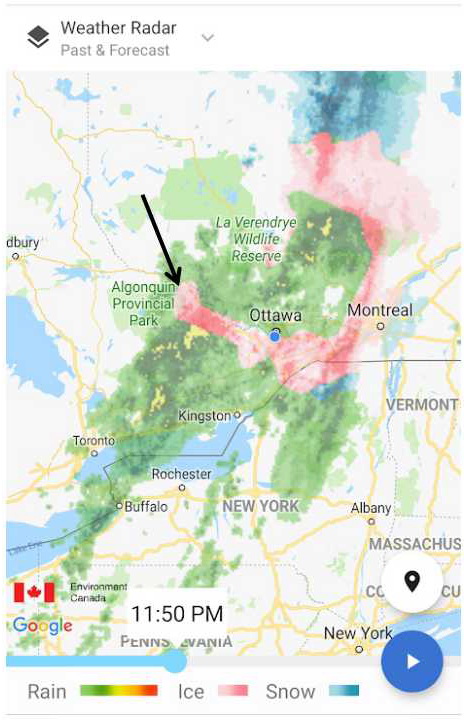
On Monday, Feb 4/19, the weather map (see photo 2) showed a tongue of freezing rain (pink colour on the map) extending to the northwest along the Ottawa Valley - the Ottawa-Bonnechere Graben valley. This is a simple explanation, but it was an excellent illustration of local geological influence on local weather.
Photo 2: A tongue of freezing rain, identified by the black arrow and the pink colour extends to the northwest from Ottawa, along the Ottawa - Bonnechere Graben valley. Image source: screen capture from The Weather Network (https://www.theweathernetwork.com/ca), captured Feb 4/19.
By the way, this is not the only way freezing rains forms. In fact, on Photo 2, there is a second band of freezing rain to the north that formed at the interface between snow, to the north, and rain to the south. This is a common location for freezing rain - at the interface between a mass of cold air and snow and a mass of warm, moist air.
Have A Question About This Note?
Andy Fyon, Feb 7/19.


