Great Meteor Hotspot: Ouch - that spot is hot!
I never owned a lava lamp, but I love watching them. They can be mesmerizing. We used to make a poor equivalent in the classrooms of the far north to model what a blob of magma might look like as it rose through the Earth.
But this note is not about lava lamps. It is a follow-up to a question I was asked by a colleague from Webequie First Nation - Jamie Spence. Jamie asked about the origin of kimberlite rocks in the James Bay Lowland area - something that a lava lamp may help us visualise.
Mantle Plume:
That story starts with a plume, or column, of superheated rock that rises from the edge of the Earth’s core, about 2900 km (1800 miles) below the Earth's surface (Photo 1). That plume is a bit like a lava lamp. As the plume approaches the surface of the Earth, the plume top spreads laterally, like the head of a mushroom, and begins to melt. The melting creates some really unusual igneous rocks (igneous = formed from magma of melted rock) such as: a) ocean islands, like Hawaii and Iceland; b) enormous volumes of flood basalt that cover large areas of the Earth’s surface, like the “Deccan Traps” in India; c) volcanic mountains on the seafloor, like the New England seamounts; d) unusual intrusions, like the Monteregian Hills in southern Quebec; and e) kimberlites, like those located in the James Bay Lowlands and Temiskaming area of Ontario, some of which contain diamonds. Geologists call the top of the plume a hotspot …. because it is hot.
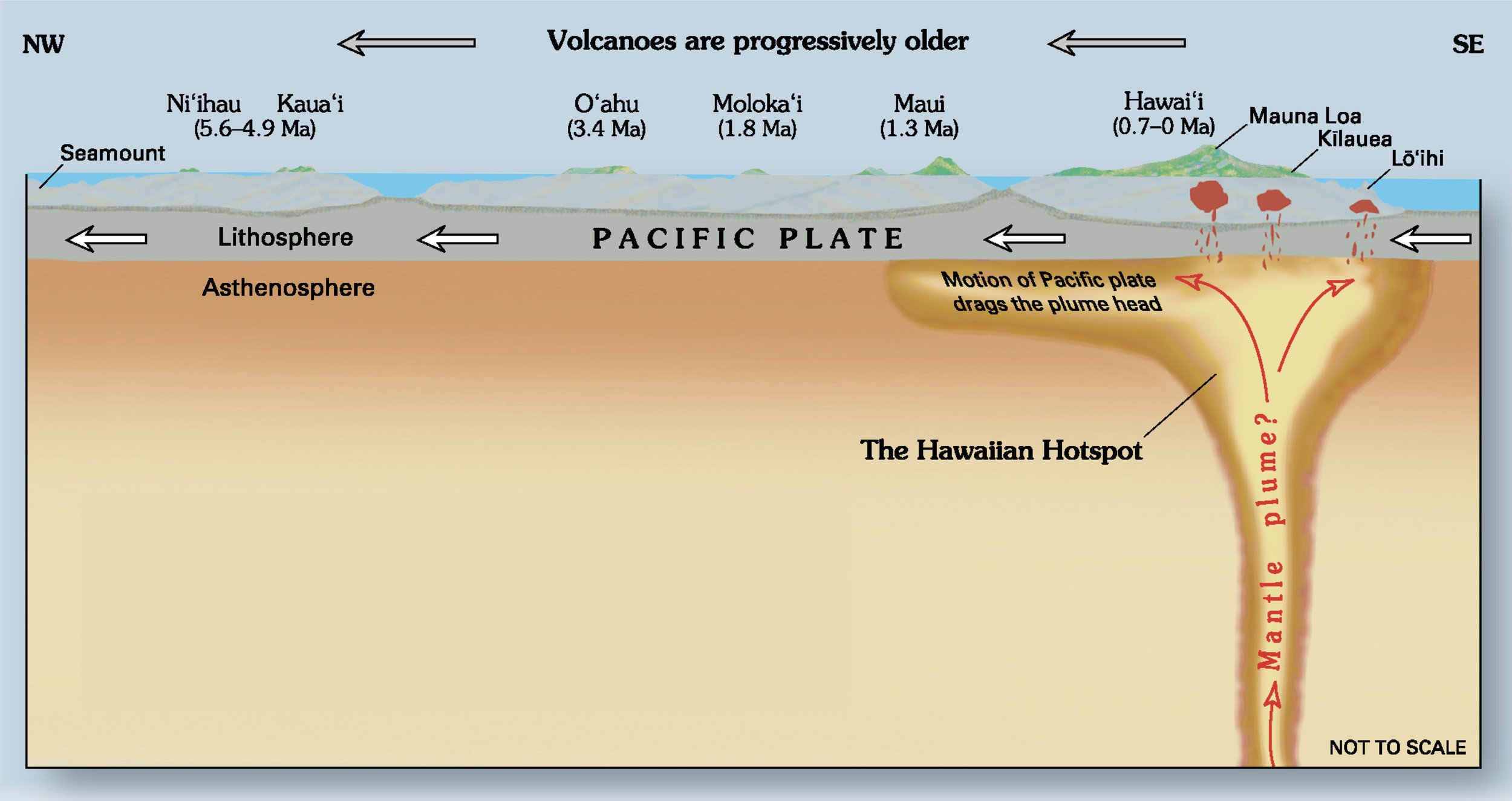
Photo 1: A cartoon that illustrates a mantle plume and related hotspot that rises from the edge of the Earth’s core to the Earth’s surface. The plume-associated igneous rocks are basalt that form the Hawaiian islands. Note that the ocean islands get older to the left, or northwest, because the Pacific plate is moving in a northwesterly direction, carrying the islands away from the hotspot melting. Image from https://en.wikipedia.org/wiki/Hawaii_hotspot
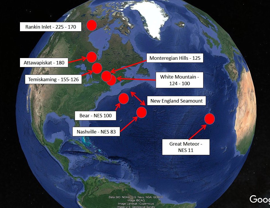
But there is more. The surface of the Earth is broken up into geological plates. The plates move slowly, about as fast as your fingernail grows, pushed and pulled by great plate tectonic forces. When a plate moves over a stationary hotspot, those unusual igneous rocks accumulate on the plate, directly above the hotspot. As the plate continues to move beyond the hotspot, a trail of increasingly older, plume-related igneous rock is created increasingly farther away from the hotspot. We see an example of this time-related trail of increasingly older plume-related rock created by the Great Meteor Hotspot (GMHS for short) (Photo 2). The GMHS is now located under West Africa, but it left a record across eastern North America and across the Atlantic Ocean.

Photo 2: The trail of plume-related igneous rock created by the Great Meteor Hotspot, also known as the New England Hotspot, is shown by the red dots. The numbers are the ages of the hotspot-created igneous rock. The oldest rock is the Churchill kimberlite field, located west of Rankin Inlet, which are 225 to 170 million years in age. Moving towards the south and east, we encounter: a) 180 - 174 million year old kimberlites in the James Bay Lowlands; b) 165 to 126 million year old kimberlites in the Temiskaming area of Ontario and Quebec; c) 125 million year old intrusions of the Monteregian Hills, in southern Quebec; d) 124-100 million year old White Mountain in New Hampshire; e) 100 million year old Bear seamount at the western end of the New England seamount chain, Atlantic Ocean; f) 83 million year old Nashville seamount at the eastern end of the New England seamount chain, Atlantic Ocean; and g) the 17 - 11 million year old Great Meteor Seamount, located off the west coast of Africa. Today, the Great Meteor Hotspot and plume is located beneath West Africa. The trail of plume-related igneous rock was created as the plate moved westerly, over the stationary Great Meteor Hotspot. Image: Dates from published literature placed on a Google earth image.
Recall, the plates move over a stationary hotspot, so, to find the oldest GMHS-related igneous rock, we have to look west … look way west. The oldest rocks related to the GMHS are the Churchill kimberlites, located west of Rankin Inlet (Photo 2), which range from 225 to 170 million years in age - a long way from West Africa. The youngest rock related to the GMHS is the 17-11 million year old Great Meteor Seamount, located in the Atlantic Ocean, just off the west coast of Africa. The trail of increasingly older GMHS-related rock, seen from just west of Africa to the Canadian Shield is exactly what is expected when a plate moves to the northwest over the stationary GMHS plume (Photo 2).
Hotspots And Us:
Hotspots impact our lives. The Hawaiian islands, a popular tourist destination, were created by a hotspot, which periodically erupts today! Closer to Ottawa, earthquakes in a zone called the Western Quebec Seismic Zone, located close to the border with Ontario, are thought to be related to ancient activity of the GMHS. The resultant earthquake risk is factored into earthquake reinforcement requirements of the Quebec and Ontario building codes.
Some igneous rocks created by the GMHS contain unusual minerals and commodities, like diamonds in kimberlite rock near Attawapiskat and niobium (used in jet engines) and perovskite (used in solar cells) in carbonatite rock near Oka, Quebec.
The GMHS-created New England Seamount chain, located off the east coast of North America, are seafloor volcanic mountains that have very diverse fauna and microorganisms, some of which were the target of deep sea commercial fishing. These seamounts were even used as submarine hiding spots during World War II and the following cold war. The GMHS has been “stirring the pot” for at least 200 million years.
So, sometimes really big geological processes are responsible for local geological features that influence our daily lives.
Facebook: Dec. 28/21.