
Ontario: The Geological Story of The Historic Lyndhurst Bridge
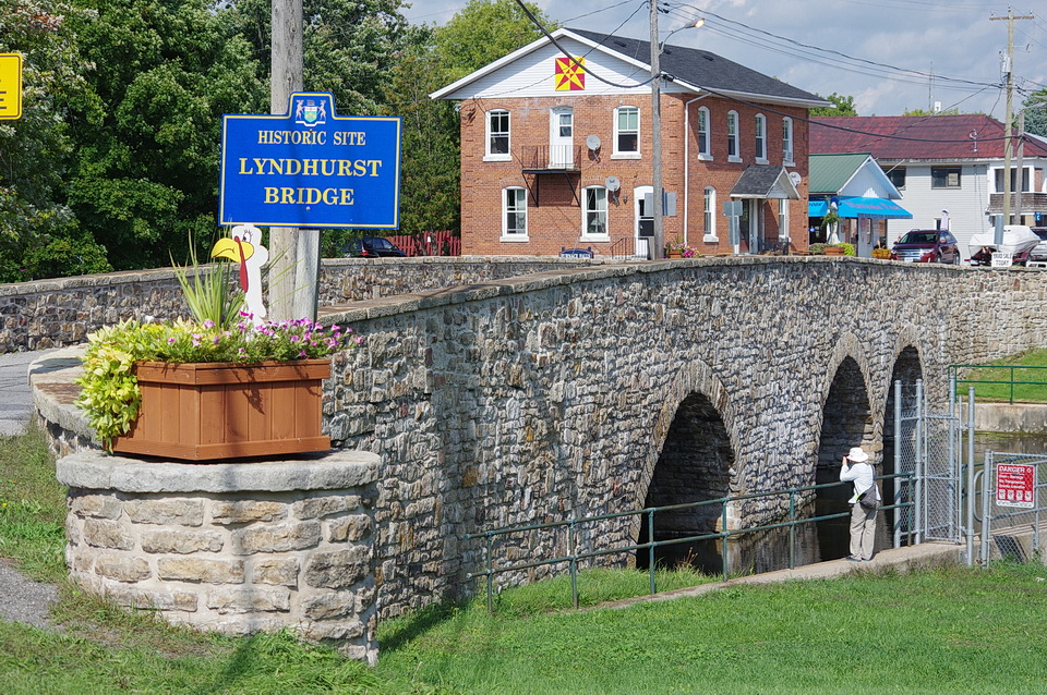
Figure 1: The historic Lyndhurst Bridge, located in the village of Lyndhurst, Ontario, is reported to be Ontario's oldest stone bridge. Photo by Andy Fyon, Sept 18/16.
Historic Lyndhurst Bridge - Ontario's Oldest Stone Bridge
The historic Lyndhurst stone bridge (Figure 1) is reported to be Ontario's oldest stone bridge. It was built between 1856 and 1857, ten years before Confederation. Is there a geological story behind this old historic bridge? Simply stated - yes.
The bridge is made of rock that was available locally. Some of the rock is a distinctive sandstone called the Potsdam or Nepean sandstone. That sandstone formed about 500 million years ago during an important change in Ontario's geological record. Other pieces of rock used to build the bridge appear to be older, perhaps 1 billion years in age, and some slightly younger than the Nepean sandstone. From a construction perspective, those different rocks were locally accessible and provided the needed engineering properties required to construct a strong bridge across Lyndhurst Creek.
Engineering Features
From an engineering perspective, the Lyndhurst Bridge is a three-span stone arch bridge (Figure 2). The unique stone bridge was designed by John Roddick, who was employed by a local mill owner (Figure 3). The bridge was built by Miles Fulford and Simon Ransom.
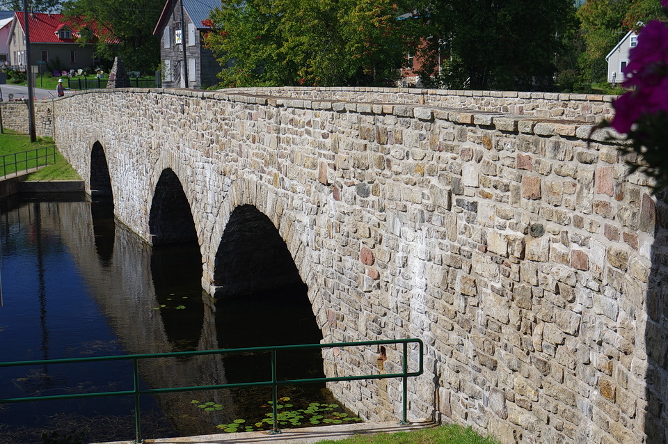
Figure 2: The historic Lyndhurst Bridge is a three-span stone arch bridge that is constructed of local fieldstone. Photo by Andy Fyon, September 2016.
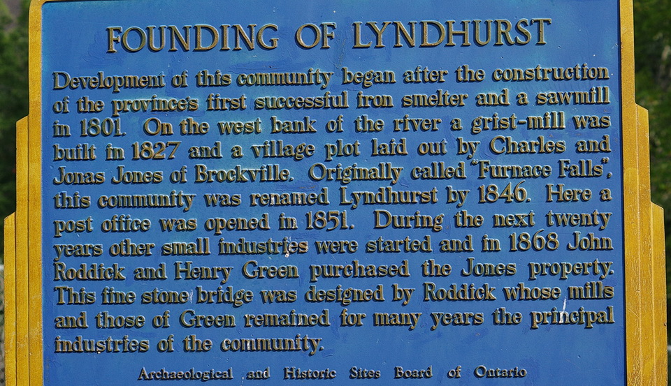
Figure 3: The Historic sign, which describes the history of the Lyndhurst Bridge. Photo by Andy Fyon, September 2016.
The three spans were built using local fieldstone (Figure 2). Fieldstone means rock pieces that were collected from the surface of nearby fields, where the rock occurs naturally and is easily accessible. Using fieldstone meant that there was no need to create a quarry to excavate rock. Building a quarry and excavating rock was not a simple task in 1856, when all the work would have been done by hand and modern drills and blasting techniques were not available.
The bridge is distinguished by the curved flare of its end walls (Figure 4) and by the slightly oblique shape of two of its arches. I could not recognize the oblique shape of the arches, but I will check during a future visit. Arches are well known to engineers. An arch is a very strong structure that is used to span open spaces, such as rivers, valleys, or to hold up open parts of buildings. Engineering that used arches began as far back as the 2nd millennium BC. The Ancient Romans applied arch engineering to construct bridges and aquaducts.
At the eastern ends of the Lyndhurst bridge, circular sandstone stones mark the ends of the bridge (Figure 4; the flower planter sits on one of the circular stone). These circular stones are reportedly mill stones that came from a local grist mill operated by Henry Green. Henry Green and bridge designer John Roddick were two noteworthy people in the community who operated mills.
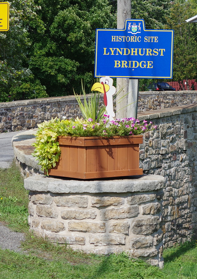
Figure 4: The eastern end of the Lyndhurst Bridge is characterized by a curved flare of its end walls. The circular stone beneath the flower planter is a mill stone, made of Nepean sandstone, that is reported to have come from a local grist mill.
It is reported that the bridge was strengthened in 1986 by the addition of a load-bearing concrete slab frame inside the deck system to accommodate heavy traffic. Despite this modern engineering modification, the bridge retains its historic appearance with no major surface alterations. The bridge remains in regular use today (summer 2016).
Geological Features
The rock geology of the Lyndhurst bridge area is complex (Figure 5). Many local fieldstone rock types were used to construct the bridge. Fieldstone rock types that were used to construct the walls of the bridge appear to consist of both the older (older than 1 billion years old) and younger (500 million and younger in age) rock types that occur in the area: Old Rock types consist of: a) light brown-coloured sandstone - possibly rock type A or E in Figure 5; b) dark to rusty-coloured, banded rock containing shiny tiny plates of a mineral called mica - likely rock type A in Figure 5; c) grey to light-coloured limestone and dolomite - rock type B in Figure 5); and d) pink-coloured rock representing pieces of the local pink granite pluton (technically, it is a called monzonite) - rock type D in Figure 5. Another young rock type used on the bridge is the light-coloured sandstone that caps the bridge walls and the round grist mill sandstone at the east end of the bridge. This young sandstone cap and grist rock appears to be the 500 million year-old sandstone called Nepean sandstone (rock type E in Figure 5).
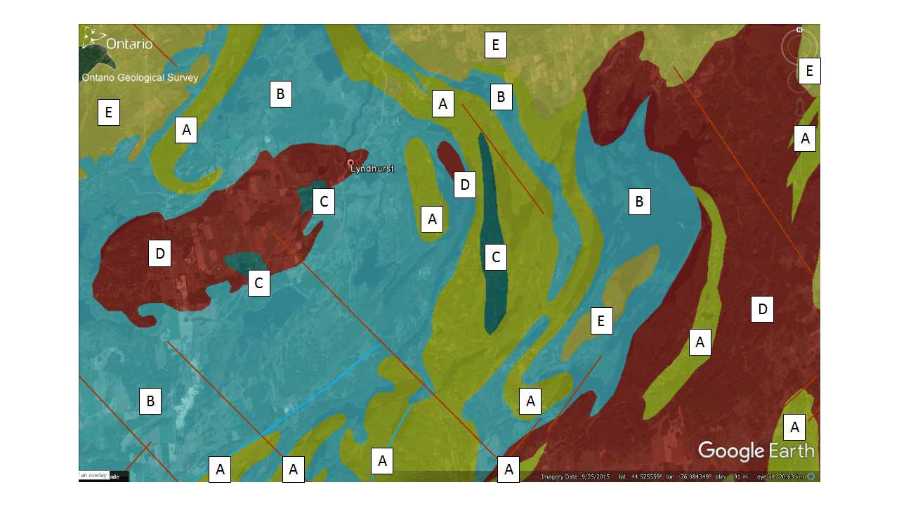
Figure 5: Rock geology of the Lyndhurst bridge area. Geologists use different colours to represent different rock types. Here is the explanation of the colours: Very old rocks (Grenville Province - greater than 1 billion years old): A: Sedimentary rocks made up from broken and weathered pieces of older rock (Clastic metasedimentary rocks consisting of conglomerate, quartz arenite, arkose, limestone, siltstone, chert, minor iron formation of the Grenville Supergroup and Flinton Group); B:Limy dolomite and limestone rocks that formed on the bottom of a warm tropical ocean (Carbonate metasedimentary rocks. Marble, calc-silicate rocks, skarn, tectonic breccias. Grenville Supergroup and Flinton Group); C: Dark coloured iron- and magnesium-rich rock that formed by cooling, below the surface of the Earth, of partially melted pre-existing rock (Mafic to ultramafic plutonic rocks; Diorite, gabbro, peridotite, pyroxenite, anorthosite, derived metamorphic rocks); D: Light-coloured, sometimes red in colour, rock that formed by cooling, below the surface of the Earth, of partially melted pre-existing rock (Late felsic plutonic rocks. Granitic gneisses with metasedimentary xenoliths, migmatites, injection gneisses, pegmatites); and Younger rock that is about 500 million years old: Sedimentary rocks made up from broken and weathered pieces of older rock (Conglomerate, sandstone, shale, dolostone. Potsdam Group; Nepean Formation; Covey Hill Formation). The geology map comes from the Ontario Geological Survey using their OGS Earth online database.
The use of local geological fieldstone rocks that met the engineering requirements likely kept construction costs down because there was no need to transport the rock over great distances and no need to develop large quarries to excavate the rock.
Quiz
Look closely at the walls of the Lyndhurst bridge and see how many different rock types you can see (Figure 6).

Figure 6: A close-up look of the different types of fieldstone that were used to build the Lyndhurst bridge. Photo by Andy Fyon, September 2016.
You don't need to be a geologist to identify the rock types. Just use your detective skills to describe each different rock type that you see, based on the colour, the way the rock has broken, its smooth or rough surface, and any other surface feature you see! Then check the Ontario Geological Survey (OGS) Earth bedrock map for the area to see just how complex the Ontario Beneath Our Feet for this area really is!
Have A Question About This Note?