
Mixed Water Bodies: Pic River and Lake Superior
Have you ever wondered if you can see the mixing of two different water bodies? You can see the mixing where one water body is distinctly different in colour compared to a second water body.
Here is an example, in the homeland of Biigtigong Nishnaabeg (Ojibways of the Pic River First Nation). The brown-coloured Pic River flows into Lake Superior, which is clear and blue-coloured in sunlight (Photo 1).
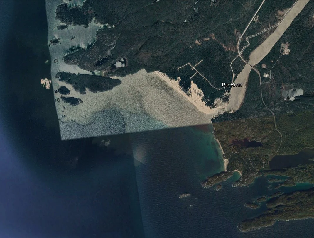
Photo 1: A Google Earth composite satellite image that shows the brown-coloured Pic River and the dark blue-coloured Lake Superior water body. The brown colour of the Pic River is caused by suspended clay and silt minerals that were eroded by the river as it passed through the watershed.
Why is the Pic River so brown? No, it is not pollution. The brown colour is quite natural. The Pic River watershed drains an area underlain by clay, silt, and other brown-coloured deposits left behind by an ice sheet during the last ice age. As the Pic River winds through its watershed, the river erodes these glacial sediments. Once eroded from the land, the glacial sediments are broken into their fine grained clay and silt mineral grains, which are transported by the Pic River out into Lake Superior. The suspended clays and silts give the Pic River its brown colour (Photo 2).
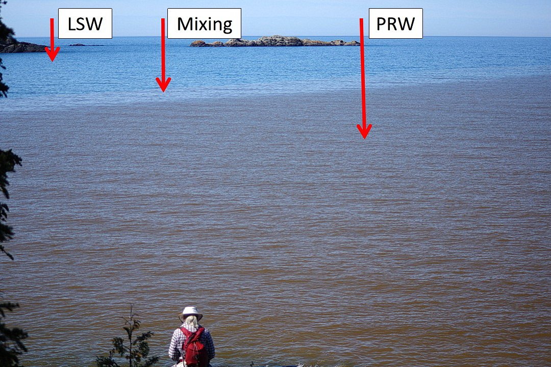
Photo 2: The brown-coloured water body in the foreground comes from the Pic River (PRW arrow) The brown coloured water reflects the clay and slit minerals that are suspended and transported by the Pic River. The blue-coloured water in the distance is clear, Lake Superior water (LSW arrow). A light brown coloured water transition between the blue and darker brown water bodies likely marks the mixing between the clear Lake Superior water and the brown-coloured, sediment suspended Pic River water body (Mixing arrow). Photo composed by Andy Fyon, near the mouth of the Pic River, seen from Pukaskwa National Park, Ontario, Canada, June 8/22.
Along its river course, the Pic River has enough “energy” to suspend and carry the clay and silt minerals, but once the river enters Lake Superior, some changes occur: 1) no new mineral material is added to the river water; 2) the Pic River slowly loses its ability to suspend and transport the clay and silt minerals, which then slowly accumulate on the Lake Superior floor; and 3) clear Lake Superior water mixes and dilutes the brown-coloured Pic River water, creating less brown-coloured water (Photo 2: mixing arrow). Over time, these processes transform the brown-coloured Pic River water into clear-coloured water, as it mixes with the clear Lake Superior water. But, before that time, the boundary between the Pic River water and the Lake Superior water is quite distinct (Photo 2).
These examples help us to see the boundaries (Photo 3) between two water bodies and tell us something about the nature of surficial materials (aka “soils”) that comprise a watershed.
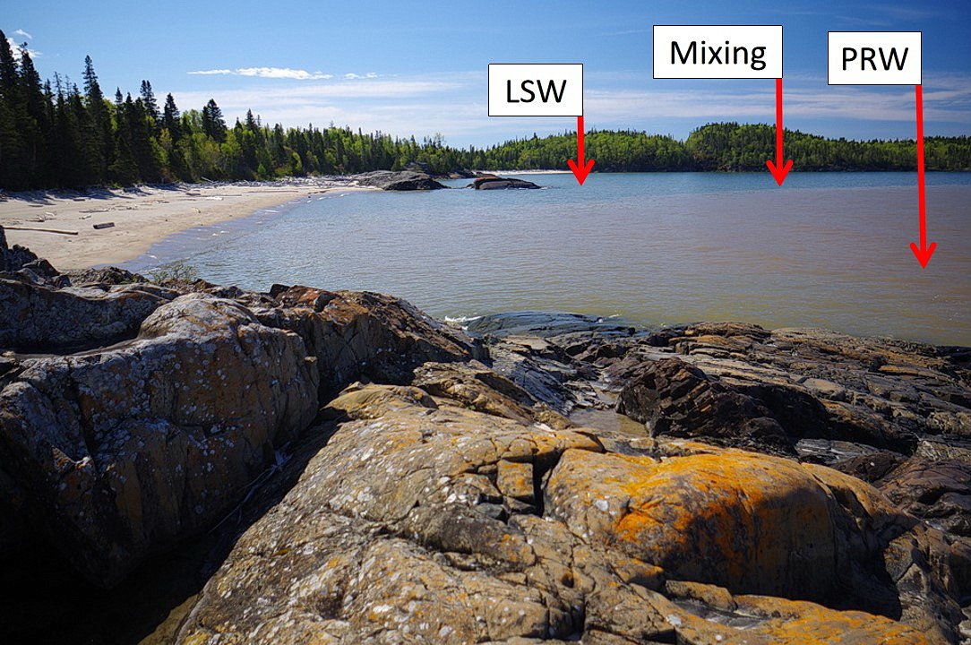
Photo 3: The boundary between the brown-coloured Pic River water body ((PRW arrow) and the clear Lake Superior water body (LSW) is distinct, due to the colour difference. A narrow possible mixing or dilution zone (Mixing arrow) occurs along the boundary between the two water bodies. Photo composed Andy Fyon, from Pukaskwa National Park, Ontario, Canada, June 8/22.
Nov. 6/22