
Ontario: Ottawa - Bonnechere Graben: The "Day" The Ottawa Valley Formed

The view across the Ottawa - Bonnechere Graben, from Foymount, Ontario, across Golden Lake to the Gatineau Hills that rise at the Mattawa Fault, Quebec. Photo by Andy Fyon, August 27, 2016.
Hilly Country
Have you ever been hiking in Gatineau Park? It is hilly country. Have you driven from Renfrew to Barry's Bay or Ottawa to Perth? Did you notice that you started out on generally flat land, but you ended up driving over hilly land that is part of the Opeongo Mountains? Perhaps you noticed that you drove up a particularly steep hill that took you away from the relatively flat land into the land of hills. Did you know that the flat land between Gatineau Park and the Opeongo Mountains is a valley that was created when the Earth's surface was stretched and pulled apart? The hills of the Gatineau Park and the Opengo Mountains sandwich that valley. This is the geological feature called the Ottawa - Bonnechere Graben. That stretching of the Earth's surface started about 600 million years ago. The valley that was formed controls the flow of the Ottawa River, can be a trap for cold air in the winter, and is associated with small earthquakes.
So, when and how did the did this part of the Ontario Beneath Our Feet, called the Ottawa - Bonnechere Graben, form?
The Surface Of The Earth In Motion
We have all looked at maps of the Earth that show us the present location of the continents and oceans (Figure 1). But the Earth's surface is not stationary. It is constantly moving. Plate tectonics is a geological process that constantly changes the positions of the continents, very slowly. The location of the continents was very different in the past.
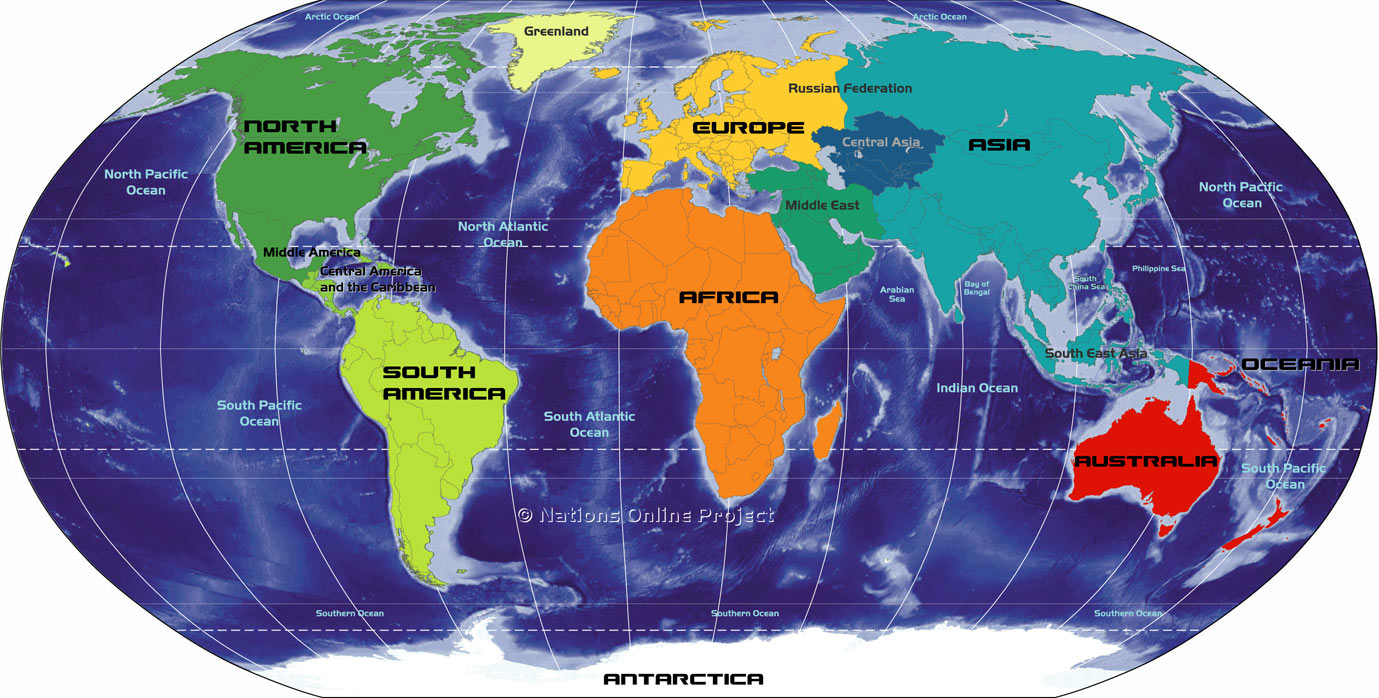
Figure 1: The location of the present day location of the continents that make up the earth. Image from: One World - Nations Online.
Supercontinent Rodinia
Imagine a little more than 1 billion years ago, when the continents of the Earth were mostly all stuck together in away that was very different compared to today (Figure 2). Land that we now call India, Australia, Antartica, North America, South America, Greenland, and parts of Europe and Asia were all joined together to make up a large supercontinent called Rodinia (Figure 2). The exact shape and history of Rodinia is sketchy because it is hard to read the history very old rocks. Geologists think that Rodinia was constructed about 1 billion years ago by the plastering together of fragments of an even older supercontinent named Columbia, one of the Earth's first supercontinents.
Supercontinents did not last forever. They came together and were broken apart by geological forces. Rodinia started to break apart about 800 million years ago (red zone in Figure 2) and continued to break apart about 600 to 550 million years ago (yellow zone in Figure 2).
The geological forces that plastered Rodinia together and tore it apart left its mark. The geological forces that tore Rodinia apart were also responsible for the creation of the Ottawa Valley. The Ottawa Valley is part of a big geological depression called the Ottawa - Bonnechere Graben and the breakup of the ancient supercontinent Rodinia was responsible for the creation of the Ottawa-Bonnechere Graben.
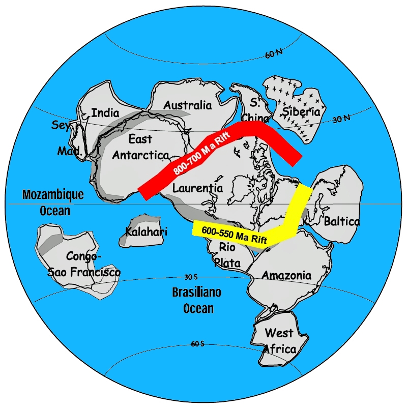
Figure 2: About 1 billion years ago, the continents of the Earth were arranged into a supercontinent called Rodinia. The red band shows where Rodinia began to break apart 800 million years ago. The yellow band shows where the remaining part of Rodinia began to break apart 600 million years ago. The breakup of Rodinia was also responsible for the creation of the Ottawa - Bonnechere Graben.
What Is a Graben:
A graben is a long valley that is created where the Earth's surface, called the crust, was stretched and pulled apart. A central valley was created when the central block of land dropped down into the space created when the land was pulled apart (Figure 3). Geologists use the term rifting to describe the process of stretching and tearing apart of the continent. The central block that drops down forms a feature called a rift valley that can contain lakes and rivers (Figure 3). Steep walls on each side of the rift valley mark the location of boundary faults. The edge of the graben is defined by these boundary faults. A fault is a crack in the crust of the Earth. Along any fault, pieces of the Earth can move up, down or horizontally past each other. In a rift valley, generally, the central block of land moves down relative to the adjacent land. Boundary faults are called normal faults. Earthquakes may occur along the boundary faults where the pieces of the Earth move past each other. The graben is about 60 km wide and 700 km long.
So, the Ottawa Valley is the central down-dropped block of the Ottawa - Bonnechere Graben.
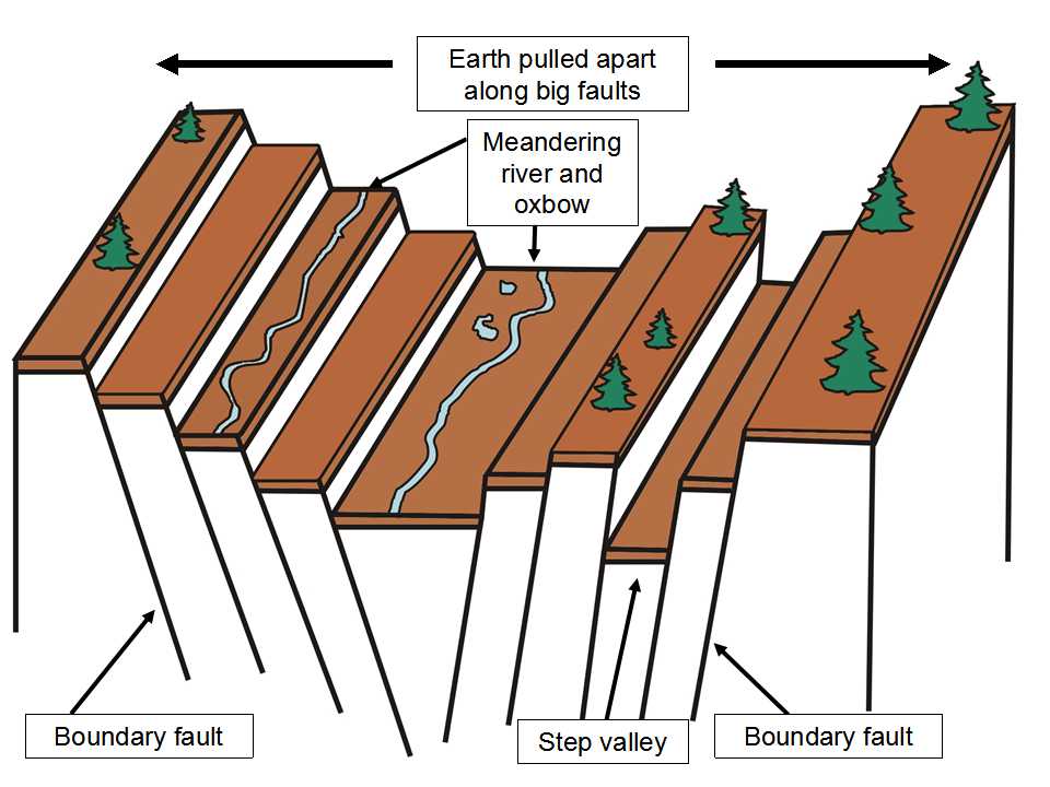
Figure 3: A cartoon that illustrates how a graben zone forms when the Earth's surface is pulled apart along big, parallel boundary faults. The central land area drops down to fill the space created when the left and right blocks spread apart. That is where a rift valley forms. Image by E. Ginn, 2016.
Boundary Of And Beyond The Ottawa - Bonnechere Graben
Two big boundary faults define the north and south boundary of the Ottawa - Bonnechere Graben (Figure 4). The northern boundary is called the Mattawa Fault. The southern boundary is called the Petawawa Fault. These faults are traced west of Lake Nipissing towards Sudbury, where the faults appear to die out. To the east, the boundary faults are traced past the City of Ottawa towards the City of Montreal, where the faults appear to link up with the St. Lawrence rift zone.
To the north of the Mattawa Fault stands the rugged Laurentian Mountains of Quebec, the remains of an ancient mountain chain. To the south of the Petawawa Fault stands the rugged Opeongo Mountains of Ontario, which are also the remains of an ancient mountain chain.
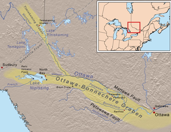
Figure 4: The geographic extent of the Ottawa - Bonnechere graben extends about 700 km from the area near Montreal, west to the area near Sudbury. The northern boundary of the Ottawa - Bonnechere Graben is called the Mattawa Fault. The southern boundary is called the Petawawa Fault. Image from from: https://en.wikipedia.org/wiki/Ottawa-Bonnechere_Graben
Birth of a Graben
So, we understand that the Ottawa - Bonnechere Graben formed from the breakup of the supercontinent Rodinia, but exactly how does the breakup of a continent cause a graben to form?
One way that a continent can break up is from the influence of a blob of very hot rock that rises from deep in the Earth. That blob of hot rock is called a mantle plume. If you could see a plume in cross section, it would look something like a mushroom cut through the button and along the stem. When the mantle plume pushed up against the bottom of the continent we now call eastern North America, the outer part of the Earth, called the crust, was pushed up like an upside down bowl. Eventually, the crust started to stretch and break apart into three pieces, much like a pie cut into three equally sized pieces (Figure 5).
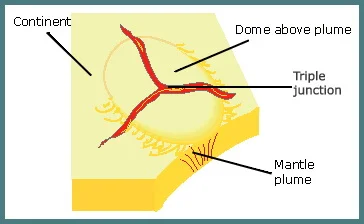
Figure 5: A triple junction forms where a mantle plume, a body of very hot rock that rises from deep within the Earth, pushes up against the bottom of the outer part of the Earth (crust). The crust breaks into three pie-shaped pieces. An "arm" separates each piece of the crust pie. Image from: wild-rocks.com
The zone between each piece of the pie is called an "arm", shown in red (Figure 5). The region where the three arms meet is called a triple junction. The pieces of broken crust are pulled apart away from each arm. Sometimes, during the breakup, one of the three arms stops spreading apart. That arm is called a "failed arm". Geologists call a "failed arm" an aulacogen. On continents and supercontinents, an aulacogen, or "failed arm", often becomes a graben.
One of the most easily recognized triple junctions on Earth today is the East African Rift (Figure 6). Here three blocks of land that are spreading away from each other meet at a triple junction in the Red Sea - Aden Gulf area (Figure 6). The Gulf of Aden and the Red Sea are spreading and will lead to the formation of a large ocean, but the East African Rift is considered to be a failed arm. The East African Rift will continue to expand its rift valley system, but geologists think that it will not develop into an open ocean.
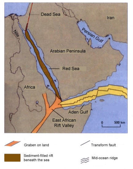
Figure 6: An illustration of one of the most easily recognized triple junctions located in northeastern Africa. Three land blocks are spreading away from each other. They meet at a triple junction. The Gulf of Aden and the Red Sea are spreading and will lead to the formation of a large ocean. The East African Rift is considered to be a failed arm, which will not develop into an open ocean.
Was The Ottawa - Bonnechere Graben Alone?
As a result of these great periods of supercontinent creation and destruction that started 800 million years ago and again at about 600 million years ago with the breakup of Rodinia and was reactivated 150 million years ago with the breakup of a younger supercontinent called Pangea, several other great rift systems developed across North America and South America (Figure 7). The rift systems in what was to become the Ontario part of North America include: a) St. Lawrence rift; b) Ottawa - Bonnechere Graben; and c) the Temiskaming Graben, which extends north to Temiskaming Shores, on the shore of Lake Temiskaming. The rift-building period created the valley landscape that now contains: a) Lake Temiskaming in the Temiskaming Graben; b) Lake Nipissing and the Ottawa River in the Ottawa - Bonnechere Graben; and c) Lake Ontario and St. Lawrence River in the St. Lawrence rift. Many other rifts were formed at this time elsewhere in North and South America. The Ottawa - Bonnechere Graben was not the only graben formed between 600 and 150 million years ago.

Figure 7: A number of large rift systems were created in what we now call North America and South America as a result of the breakup of the supercontinent Rodinia, 600 million years ago, and of the supercontinent Pangea, 150 million years ago. In Ontario, the St. Lawrence rift and the Ottawa - Bonnechere Graben were created at this time. Image from Nick Eyles (2002)
Are There Active Boundary Faults Along The Ontario - Bonnechere Graben?
One way to determine if the Ottawa - Bonnechere Graben is still active today is to look at the number and size of earthquakes that occur in, and adjacent to, the graben boundary faults. Earthquakes Canada is a Federal Government organization that monitors earthquakes across Canada and publishes summary maps of earthquake magnitude and location (Figure 8). Between the cities of Ottawa and Pembroke, along the Ottawa - Bonnechere Graben, there are several very small earthquakes (Figure 8). Most of the earthquake activity occurs to the northeast of the Ottawa - Bonnechere Graben. This suggests that the graben is not very active today.
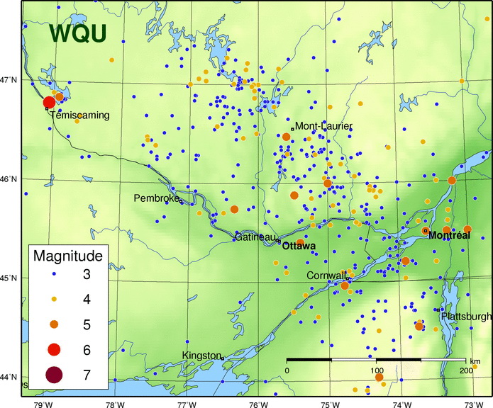
Figure 8: The image shows the location and magnitude of historic earthquakes in the area that includes the Ottawa - Bonnechere Graben. Between Ottawa and Pembroke, there are several very small earthquakes along the Ottawa - Bonnechere Graben. This suggests that the graben is not very active today. The main zone of earthquakes occurs in a northwesterly zone that starts near Plattsburg and runs towards Mount Laurier and Maniwaki (Quebec). Geologists do not absolutely understand the cause of these earthquakes. Image from: Earthquakes Canada.
Influence Of The Ottawa - Bonnechere Graben On People
Weather: Because the valley floor of the Graben is at a lower elevation compared to the Gatineau Hills and the Opeongo Mountains, cold, dense arctic air sometimes flows into, and becomes trapped in, the valley during the winter. The result is colder temperatures along the valley floor compared to the surrounding rugged hilly areas.
Dangerous Clay Of The Champlain Sea: At the end of the last ice age, a sea, called the Champlain Sea, flooded west from the Atlantic Ocean along the St. Lawrence rift and into the Ottawa - Bonnechere Graben. Unstable clay material was deposited on the bottom of the ancient sea. Today, that clay can cause construction challenges due to landslides. Groundwater in the clay is locally enriched in iodide, derived from ancient sea plants that occur in the clay. That iodide-rich groundwater may create health considerations under certain circumstances.
Agriculture: The relatively flat land in the bottom of the Ottawa - Bonnechere Graben is better suited to farming compared to the rugged land of the adjacent Gatineau Hills and the Opeongo Mountains.
Summary: Ottawa - Bonnechere Graben
The Ottawa valley area was created when the ancient supercontinent Rodinia broke into pieces about 600 million years ago. That break up stretched the surface of the Earth in a way that caused the Earth's crust to break and spread apart. Large faults were created. A central block of land dropped down along the faults to create a valley. The valley is bounded by the Mattawa and Petawawa boundary faults (Figure 4). The boundary faults and the valley define the Ottawa - Bonnechere Graben. Technically, the Ottawa - Bonnechere Graben is a "failed arm", or aulacogen. That "failed arm" was part of a triple junction (Figure 5). In addition to the creation of the Ottawa - Bonnechere Graben, the St. Lawrence rift also formed and is shown in grey colour (Figure 9).
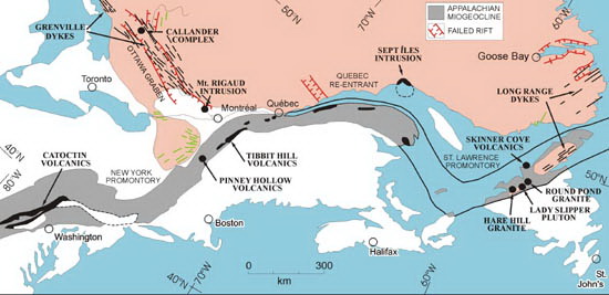
Figure 9: A cartoon reconstruction of the breakup of Roginia and the formation of the Ottawa-Bonnechere Graben (located to the right of Toronto) and other related graben zones, shown in red. Image from Per-Gunnar Andreasson et al. (2005).
The geological processes that created the Ottawa - Bonnechere Graben did not stop with the breakup of Rodinia. Northeastern North America, including the Ottawa - Bonnechere Graben, continued to be affected by the breakup of a yet another younger supercontinent called Pangea about 150 million years ago.
So, the next time you travel through the Ottawa valley, think of the great geological forces that stretched and tore apart the crust of the Earth to create the large geological feature called the Ottawa - Bonnechere Graben about 600 million years ago. That geological feature is an important part of the Ontario Beneath Our Feet, which influences human activity today, 600 million years after it started to form.
Additional Photographs Of The Ottawa - Bonnechere Graben
Image 1: The Ottawa - Bonnechere Graben Seen From Outer Space
The 700 kilometer length of the Ottawa - Bonnechere Graben is distinctive when viewed using NASA satellite imagery (Figure 10). Figure 10 is a digital elevation model for the Ottawa - Sudbury area. The image shows topographically high and low areas using colour. Green coloured areas are topographically low. Yellow and brown coloured areas are topographically high. The valley of the Ottawa - Bonnechere Graben is shown by the band of green-coloured land that runs from North Bay area (#5), along the Ottawa River to the Ottawa area (#1). The dashed red lines show the location of some of the main faults that make up the graben, including the northern Mattawa Fault and the southern Petawawa fault. The graben becomes less obvious in the west, in the Sudbury area (#6). To the east, the Ottawa - Bonnechere Graben merges with the St. Lawrence rift system, which also controls the location of the St. Lawrence River.
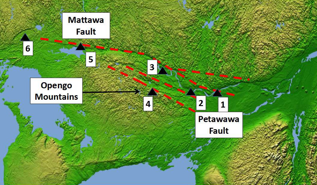
Figure 10: Shaded relief image, with colour as height. The regional distribution of the Ottawa - Bonnechere Graben, the Mattawa and Petawawa faults, and some cities: 1 = Ottawa; 2 = Arnprior; 3 = Pembroke; 4 = Foymount; 5 = North Bay; and 6 = Sudbury. Green areas are topographically low. Yellow areas are topographically high. Image from NASA.
Image 2: Petawawa Fault Between Foymount and Cormac
Figure 11 is a Google Earth image of the area looking towards the west, from a position just southeast of Lake Clear, west of Ottawa. The red line traces out the approximate location of the Petawawa Fault. That fault is the southern boundary of the Ottawa - Bonnechere Graben. Lake Clear abuts up against the Petawawa Fault. To the left of the red line (the south) is the rugged land of the Opeongo Mountains, the rugged land that lies to the south of the Ottawa - Bonnechere Graben. To the right of the red line (to the north) is flat land, which is the valley or bottom of the Ottawa - Bonnechere Graben. The flat land is sometimes associated with agriculture.
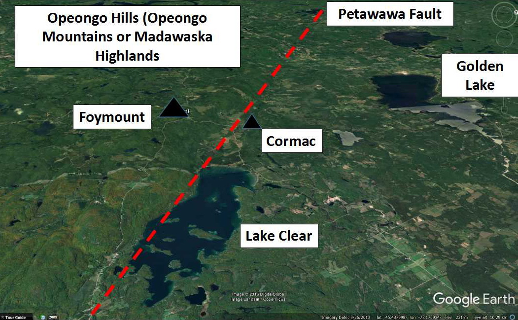
Figure 11: Looking to the west, the red line represents the trace of the Petawawa Fault, which is the southern boundary of the Ottawa - Bonnechere Graben. Image is a modified image from Google Earth.
Image 3: Drive Across The Petawawa Fault Between Foymount and Cormac
The town of Foymount is located in the Opeongo Mountains (also known as the Madawaska Highlands), approximately 125 kilometres west of Ottawa. Foymount is Ontario's highest populated point at 500 meters (1,600 ft) above sea level. Foymount sits on the old Precambrian Shield rock that is part of the Opeongo Mountains. When you drive north from Foymount, along Highway 512, you drive down a steep hill into a valley near the old community of Cormac. The valley is the floor of the Ottawa - Bonnechere Graben. The steep hill you drove down is the scarp of the Petawawa Fault - the southern boundary of the Ottawa - Bonnechere Graben (Figure 12). Look to the southeast from Cormac and you are looking along the topographic difference that defines the Petawawa Fault. The steep hill to your right (the south) is the Opeongo Mountains. The flat land to the left (the north) is the floor of the Ottawa - Bonnechere Graben.

Figure 12: Looking to the southeast from the town of Cormac, on the valley floor of the Ottawa - Bonnechere Graben, at the steep cliff, which was created by the Petawawa fault - the southern boundary of the Ottawa - Bonnechere Graben. Photo by Andy Fyon, August 27, 2016.
Image 4: Look Across The Ottawa - Bonnechere Graben From Opeongo Mountains To The Gatineau Hills
If you look north from the elevated ground that is home to Foymount (Figure 13), you see a valley that contains Golden Lake. In the distance you see an abrupt rise which is the Mattawa Fault beyond which are the Gatineau Hills. You are looking from the south side to the north side of the Ottawa - Bonnechere Graben. The flat land in between is the floor of the Ottawa - Bonnechere Graben.
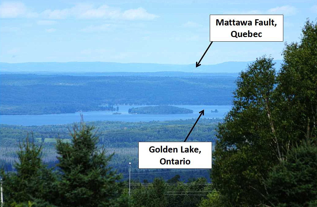
Figure 13: Looking northerly across the Ottawa - Bonnechere Graben from Foymount, on top of the Opeongo Mountains, across the Petawawa Fault (hidden by the trees in the front), across Golden Lake within the valley of the Ottawa - Bonnechere Graben, to the abrupt cliffs of the Gatineau Hills, which show the location of the Mattawa Fault. Photo by Andy Fyon, August 27, 2016.
Other Sources of Information
a) Eyles, Nick (2002): Ontario Rocks. Three billion years of environmental change. Fitzhenry & Whiteside, 339 p.
b) Per-Gunnar Andreasson, Kenneth L. Buchan, Leonid V. Shumlyanskyy, and Richard E. Ernst (2005): The Volynian Flood Basalt Province and coeval (Ediacaran) magmatism in Baltoscandia and Laurentia; Large Igneous Provinces Commission.
Have A Question About This Note?
Andy Fyon, Dec 22/16; April 6/17