
Yukon: Terminal Moraine, Brute Mountain, Yukon, Canada
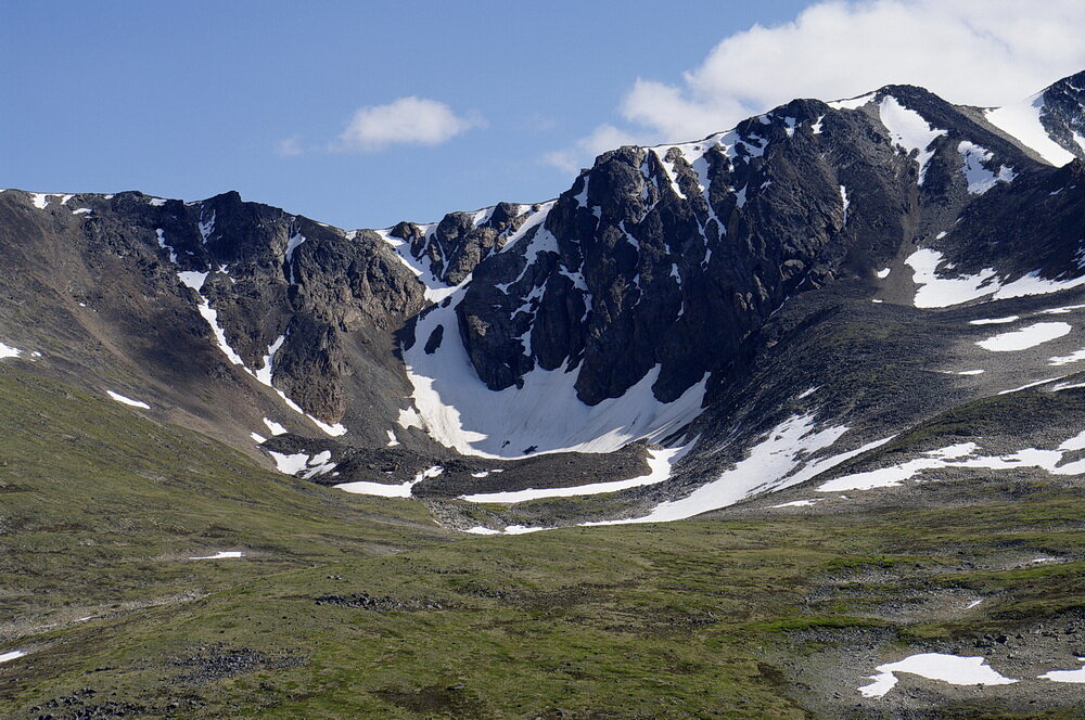
Photo 1: In the centre of the image is a curved bowl that was cut into he mountainside by an alpine glacier. That bowl is called a cirque. On the ground, in the foreground, are ridges of coarse gravel. Those ridges are called terminal moraines that marked the lines where the glacier stopped its forward movement, towards the end of the last ice age about 15,000 years ago. Photo composed by Andy Fyon, on Brute Mountain, looking west from Mount Montana area, Yukon, Canada, July 16, 2008.
Signs Left By Alpine Glaciers
The mountains south of Carcross, Yukon, Canada, display several geological features that were created by alpine glaciers in the past. Two features tell us that an alpine glacier used to occupy this area.
The bowl-shaped form is visible in the side of Brute Mountain, south of Carcross, Yukon is one of those geological features (Photo 1, above). The bowl-shaped side of the mountain, where the snow pack remains, is called an alpine cirque. The cirque was cut into the mountain by an alpine glacier during the last ice age, which peaked about 25,000 years ago in this area. This is the first clue that the area was once covered by a glacier.
Terminal Moraines
The second geological feature, which tells us a glacier used to occur here, are ridges of rock debris across the front of the cirque. The red arrows highlight three bands of boulders and debris that string across the open end of the cirque (Photo 2). The bands of rock separate the cirque from the green, alpine meadow in the foreground. Those rocky bands are called terminal moraines.
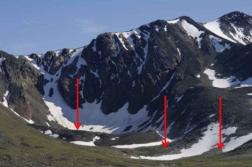
Photo 2: The red arrows point to the crests of at least three terminal moraines. The terminal moraines mark the forward limit of front of a glacier that moved forward, perhaps melted back, moved forward again, but not as far as the first advance, melted back, and moved forward one last time to create the terminal moraine closest to the centre of the cirque. All of this advancing and retreating, or melting back, likely took place towards the end of the last ice age about 15,000 years ago. Photo composed by Andy Fyon, on Brute Mountain, looking west from the Mount Montana area, Yukon, Canada, July 16, 2008.
What Is A Terminal Moraine
The terminal moraines mark three places where the alpine glacier stopped its forward movement, started to melt back, and dumped the rock debris it carried. The tallest and most distant terminal moraine, which is closest to the cirque, was likely the last advance of the glacier.
Some might also call these ridges recessional moraines. A recessional moraine is created when a glacier melts back, or retreats, and the rock debris is deposited as the glacier melts back.
Terminal and recessional moraines are made of rock debris, ranging from clay size to large boulders. The debris was carried and pushed along by the glacier that used to occupy the cirque. Some of the debris may have fallen off the steep sides of the cirque onto the top of the glacier. Other debris was picked up at the underside of the glacier. Still more debris was pushed along in front of the glacier, as it moved forward, or advanced, during cold periods.
Moraines And Ecology
The moraines are an habitat for some alpine flowers and some animals. Because the moraines contain coarse-grained material, and stand higher than the adjacent land, the moraines are porous and dry. This can be an ideal habitat for the Collared Pika (Ochotona collaris) or the Hoary Marmot (Marmota caligata), so long as a source of food is nearby, like grasses, sedges, and forbes.
Some wildflowers, like Prickly Saxifrage (Saxifraga tricuspidata), occur on the rocky substrate of a moraine.
Geological Epilog
The terminal and recessional moraines on Brute Mountain, south of Carcross, Yukon (Canada), formed in front of an alpine cirque at the snout of leading edge of a glacier and marks the maximum advance (terminal moraine) of the glacier and retreat steps (recessional moraine) as the glacier melted. Moraines are a geological feature that tells us the area was covered in the past by a glacier. Moraines serve as habitats for some wildflowers and small animals.
Location
Brute Mountain and Mount Montana are accessed by an old gravel road from the town of Carcross, Yukon. As of summer 2019, you could drive part way up to the top of the tree line and then you had to hike into the alpine. There are several cirques in the area, but the one in the photo is located approximately at: 60.0820N and -134.7340W.
Have A Question About This Note?
Andy Fyon, July 17, 2020