
Ontario: Schuss A 600 Million Year Fault, Calabogie Peaks Resort
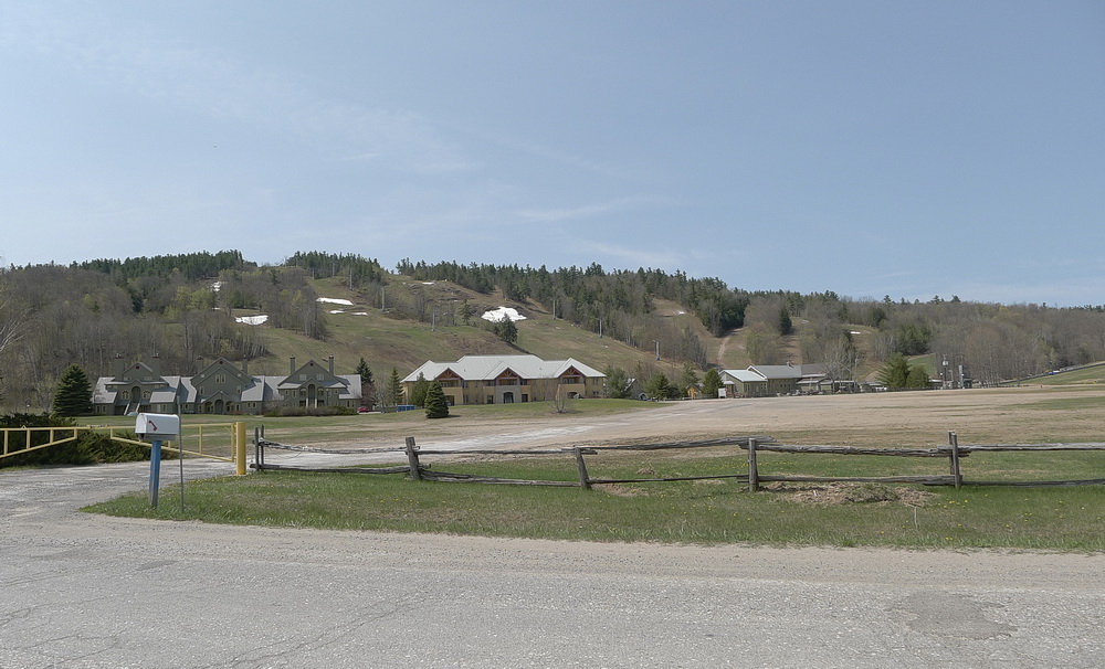
Figure 1: The view of the ski hill at the Calabogie Peaks Resort, west of Ottawa, Ontario, Canada. The flat land in the foreground is part of the floor of the Ottawa - Bonnechere Graben. The ski hill is the scarp that defines part of the Petawawa Fault, which is the southern boundary of the Ottawa - Bonnechere Graben. Photo by Andy Fyon, May 12, 2016.
Have you ever been skiing at Calabogie Peaks Resort? Why is there a ski hill there? Does the local geology - the Ontario Beneath Our Feet - have any role in creating this ski hill?
In this note, I review briefly how geological history contributed to the creation of a hill that became a famous local ski hill. The ski hill at the Calabogie Peaks Resort formed as a result of a geological event that began to pull the Earth apart about 600 million years ago! While the Earth was being stretched and pulled apart, the geological process created a 700 kilometer-long valley with steep sides. The steep valley sides mark the location of two ancient faults called the Mattawa fault and the Petawawa Fault. The surface of the Earth dropped down along that fault to create steep valley walls. One part of the steep valley wall was an ideal location for a ski hill.
Making A Ski Hill: Pull The Earth Apart
About 600 million years ago, the Earth's crust began to stretch apart when an ancient supercontinent called Rodinia began to break up. The stretching of the Earth's crust over millions of years caused a 700 kilometer-long valley to form between two large parallel faults. A fault is a crack in the crust of the Earth. Adjacent pieces of the Earth on either side of the fault can move up, down or horizontally past each other along a fault. The northern fault is called the Mattawa Fault. The southern fault is called the Petawawa Fault (Figure 2).
In the Calabogie area, the block of land between the Mattawa and Petawawa faults dropped down to form a 700 kilometer-long, relatively flat valley between those two parallel faults. Geologists call this valley a rift valley that is bounded between the Mattawa and Petawawa faults. Together, the Mattawa and Petawawa faults, and the rift valley between those faults, are called the Ottawa - Bonnechere Graben (Figure 2). The Graben is about 60 kilometers wide and extends westerly towards the City of Sudbury and easterly towards the city of Montreal - a length of 700 kilometers.
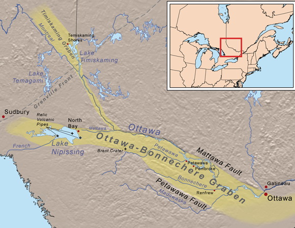
Figure 2: The geographic extent of the Ottawa - Bonnechere graben extends about 700 km from the area near Montreal, west to the area near Sudbury. The northern boundary of the Ottawa - Bonnechere Graben is called the Mattawa Fault. The southern boundary is called the Petawawa Fault. Image from from: https://en.wikipedia.org/wiki/Ottawa-Bonnechere_Graben
In detail, the Calabogie Peaks Resort ski hill is located west of Ottawa, on the southern edge of the Petawawa Fault (Figure 3).

Figure 3: This Google Earth image shows the elevation of the land using grey colours. It is called a greyscale image. In this type of image, flat land is show by uniform light grey colour that does not contain tiny pointed mountains. Hilly land is shown by light and dark areas that resemble a shadow case by a hill. The image is oriented as though you are looking to the west from an airplane located to the east of Calabogie Peaks Resort. The location of the Petawawa Fault is shown by red dashed lines. To the south of the Petawawa Fault (left of the dashed red lines) is hilly land called the Opeongo Mountains. To the north of the Petawawa Fault (right side of image) is relatively flat land of the rift valley, which forms the floor of the Ottawa - Bonnechere Graben. Calabogie Peaks Resort (black triangle) and Calabogie Lake are located in the lower left side of the image. Image from OGS Earth using elevation data acquired from NASA through the Shuttle Radar Topography Mission (http://www.mndm.gov.on.ca/en/mines-and-minerals/applications/ogsearth/elevation).
Ottawa - Bonnechere Graben
The Ottawa - Bonnechere Graben (Figure 2) with its rift valley formed when the land was stretched and started to pulled apart about 600 million years ago. The block of land between the bounding Mattawa and Petawawa faults dropped down relative to the edges, along the faults. Steep valley sides were created along the fault scarp. The Graben is about 700 kilometers long and 60 kilometers wide.
To the north of the Mattawa Fault stands the rugged Laurentian Mountains of Quebec, the remains of an ancient mountain chain. To the south of the Petawawa Fault stands the rugged Opeongo Mountains of Ontario, which are also the remains of an ancient mountain chain. The Mattawa and Petawawa faults run to the west towards the City of Sudbury, where the faults appear to die out. To the east, the boundary faults are traced past the City of Ottawa towards the City of Montreal, where the faults appear to link up with another valley that contains the St. Lawrence River. That valley is called the St. Lawrence rift zone.
For more insight about Ottawa - Bonnechere Graben, see the page entitled "Ottawa - Bonnechere Graben".
Making A Ski Hill: Elevation Difference
The elevation difference between the top and bottom of the rift valley is essential to make a ski hill. The Calabogie Peaks Resort lies on the southern edge of the Ottawa - Bonnechere Graben (Figure 3). In the area of the ski hill, the Petawawa Fault has several branches, one of which passes beneath the land at the south edge of the parking lot (Figure 1). The flat parking lot area, the lodge buildings, and Calabogie Lake occur to the north of the Petawawa Fault, on the floor of the relatively flat rift valley. To the south of the Petawawa Fault lie the hilly Opeongo Mountain rocks (Figure 3). The hilly land of the Opeongo Mountains remained more or less remained stationary when the Earth was pulled apart to create the rift valley.
The formation of the Ottawa - Bonnechere Graben is the geological process that created the elevation difference between the rugged, hilly Opeongo Mountains south of the Petawawa Fault, at the top of the ski hill, and the relatively flat rift valley floor located to the north of the fault, at the bottom of the ski hill (Figure 4).
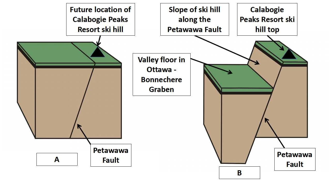
Figure 4: Creation of the Calabogie Peaks Resort ski hill. Step A: the land begins to get stretched and the Petawawa faults is created about 600 million years ago. Step B: the land is dropped down along the Petawawa Fault to created the Ottawa - Bonnechere Graben. The steep walls of the rift valley create the elevation difference needed to make a ski hill. The base of the ski hill lies at the edge of the rift valley floor in the Ottawa - Bonnechere Graben. Image created by E. Ginn
Rounding During The Ice Age
The final shape of the ski hill that we see today was smoothed and contoured by the grinding action of a glacier that covered all of Ontario during the last ice age. The weight and thickness of the glacial ice wore down the hard rock, much like sandpaper wears down a piece of wood. That ice age ended about 15,000 years ago.
Is The Petawawa Fault Dangerous?
You might wonder if it is safe to ski over a fault that had such a dramatic affect on the land. Evidence collected by Earthquakes Canada, a Federal Government organization that monitors earthquakes across Canada, tells us that the Petawawa Fault is not very active today. Between the cities of Ottawa and Pembroke, along the Ottawa - Bonnechere Graben, there are several very small earthquakes, which do not present a serious threat to humans. So, you need not worry about the Earth moving beneath your skis - except movement created by your schussing down the hill.
Summary: Making the Ski Hill at Calabogie Peaks Resort
The ski hill at the Calabogie Peaks Resort formed as a result of a geological event that began to pull the Earth apart about 600 million years ago! While the Earth was being stretched and pulled apart, the geological process created a 700 kilometer-long valley with steep sides called the Ottawa - Bonnechere Graben. The steep valley sides mark the location of two ancient faults called the Mattawa fault and the Petawawa Fault. The surface of the Earth dropped down along that fault to create steep valley walls. The ski hill is located on one part of the Petawawa Fault. The top of the ski hill is located on rocks that are part of the Opeongo Mountains, which lie south of the Graben. The base of the ski hill, where the resort buildings and parking lots are located, occur on the floor of the rift valley within the Ottawa - Bonnechere Graben. The Petawawa Fault lies where the base of the hill meets the flat land by the parking lot. The surface of the Earth was dropped down along the Petawawa Fault to create the valley with steep walls. This is an ideal location for a ski hill because of the elevation difference between the top and bottom of the ski hill, across the ancient Petawawa Fault.
So, the next time you schuss down the ski hill at Calabogie Peaks Resort, think of the great geological forces that stretched and began to tear apart the Earth about 600 million years ago, in this area we now call Ontario. Although the Ottawa - Bonnechere Graben is part of the "Ontario Beneath Our Feet", the steep slope created along the Petawawa fault is very visible on surface and contributes to a popular winter recreational activity called skiing.
Have A Question About This Note?
Andy Fyon, Jan 8/17; April 6/17